
The Saltmarsh Project

Logos of Bioregional learning centre, Environment Agency, South Devon National Landscape, Dart Harbour, Devon Wildlife Trust, Duchy of Cornwall, Parklike, Devon Biodiversity Records Centre, 5Rivers and UK Centre for Ecology & Hydrology

This is a joint project, funded by the Environment Agency, led by Bioregional Learning Centre, South Devon National Landscape and Dart Harbour, with the support of  Devon Wildlife Trust, Duchy of Cornwall, Parklife, Devon Biodiversity Records Centre, 5Rivers and UK Centre for Ecology & Hydrology amongst other organisations and landowners.

This page concentrates on the on-site restoration work that is taking place.  Further information about the background of the project and the artistic impact of Saltmarshes can be found here

If you have questions about this project, feel free to email [email protected] and we will direct your query to the appropriate project partner.

Long Marsh

View of habitat from beginning of existing walkway, next to tidal gate.

Site location: Long Marsh – Totnes East Bank

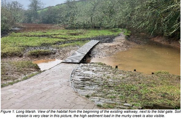
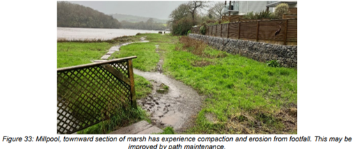
Description: Long marsh is a small strip of semi-improved grassland and saltmarsh with limited hydrological connectivity to the estuary. The hard defences and raised banks of the 1830s subsequently disconnected the wetland from river, resulting in a transition to a more terrestrial habitat. In the upper reaches of the site, is mixed scrub and semi-improved grassland. Centrally, the area is dominated by Bolboschoenus maritimus swamp with rare occurrence of Scirpus tabernaemontani, Atriplex prostrata and other saltmarsh species. At the edges of the stream and on decaying wood, there are some species indicative of brackish conditions but the community is mainly Agrostis stolonifera subcommunity mixed with  mesotrophic grassland. These communities indicate that there is rare saline inundation. The stream appears to have a high level of suspended sediment, possibly due to the runoff from the catchment during periods of high rainfall. There is considerable path erosion from frequent footfall, maintenance of paths would likely strongly benefit the vegetation and reduce soil erosion.

Work Completed: > On site survey.

Work Planned: > Installation of an accessible boardwalk from the south end of the riverside footpath around the saltmarsh area.  This is a significant project that will be carried out in conjunction with South Hams District Council.

> Opening up of existing sluice to allow more frequent salt water inundation of marsh

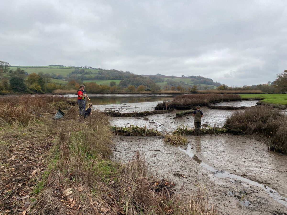
> Leaky Dams upstream in stream, to help mitigate flooding and manage sediments

> Provision of improved site information.


Home Reach

Site location: Home Reach – Totnes East Bank

Description: Home reach marsh is a narrow band of brackish marsh partially maintained by grazing geese. The inland section is bounded by a line of trees, including some deadwood. The marsh is dominated by Agrostis stolonifera community and on brief inspection appeared to have a variety of other transitional saltmarsh plants. The marsh also contains patches of Bolboschoenus stands and Phragmites marsh in the lower section. Patches of Bolboschoenus maritimus persist on the mudflat where sections have previously collapsed. At the edges of the marsh, many invertebrate burrows were visible, indicating that this is an important intertidal refuge which may be important for predators. There is a large network of channels throughout the marsh, keeping it well hydrologically connected, though this could result in some problems with drought.

Work Completed: > On site survey.

> Installation of sedimentation monitor to help us understand the rate of sedimentation and fine tune our saltmarsh restoration works.

Work Planned: > Installation of brushwood / coir / natural material barriers in the openings of larger channels, to facilitate accumulation of sediment in the channels

>LIDAR (Laser measuring drone) level survey to give us a super accurate heights map of the saltmarsh for future monitoring

40ft Off

Site location: near to 40ft Off red marker post – East Bank north of Sharpham North Quay.

Description: Opposite the buoy is a larger but heavily degraded stretch of marsh on the left bank. The intact sections of marsh holds a diverse short sward community, presumably grazed by geese. There are many standing pools containing a dense array of small invertebrate burrows. Large sections of the marsh have collapsed due to undercutting of edges and recent block collapse in places, but Bolboschoenus stands persist on some of the islands and lower sections which smooth out into mudflat areas. There is a large stand of Phragmites on the middle section of the marsh. The downstream sections have degraded into islands though none of degradation appears to be recent..

Work Completed: > On site survey.

> Installation of sedimentation monitor

Work Planned: > Installation of brushwood / coir / natural material barriers in the openings of larger channels, to encourage accumulation of sediment in the small channels to help restore areas of saltmarsh.”

>LIDAR level survey

>Creation of small island of additional saltmarsh habitat downstream of existing marsh within the boundaries of the saltmarsh area using polders made of brushwood, as a test of concept for encouraging the restoration of a larger saltmarsh at The Gut site.

Fleet Mill Creek

Site location: Fleet Mill Creek – East Bank behind Paddle Steamer Dam.

Description: Fleet Milly quarry is a an historic tidal creek of the estuary, blocked off with a seawall to become a freshwater lagoon but recently breached and presently reverting to its original tidal conditions,  bounded by a wall and a breached sluice. The Northern edge of the site is bordered by wet woodland, which according to the survey is in decline around the edges of the marsh, possibly due to saline intrusion. Bordering this wet woodland is a diverse reedbed with rare occurrence of brackish species, indicating a strong riparian (freshwater stream) influence with some saline intrusion. Below this zone, is a species-poor reedbed dominated by Phragmites, bordered with ditches and some raised banks home to Blackthorn scrub and Pendunculate Oak, some of which are dying back. Parts of this marsh are grazed by cattle.

A fringe of drier semi-natural woodland follows the edge of the marsh, which is potentially exposed to saline intrusion The reedbed smooths out into an intertidal mudflat habitat where Little Egrets have been seen foraging.  There is some loss of the southern bordering reedbed and willow scrub. On the southern side of the site, the mudflat rises up to a wall at which there is frequent occurrence of saltmarsh species such as Bolbschoenus maritimus, Triglochin maritima and Aster. Closer to the inlet channel, there is some occurrence of Spartina, Puccinellia and plenty of fucoid algae.

On the estuary side of the wall, lies a paddlesteamer, left there in 1923 and since colonised by a well establish saltmarsh community including Bolboschoenus maritimus and Spartina. The decay of the boat has resulted in some of the mud washing out, reducing the overall coverage. The recent die-off of vulnerable marsh has caused retreat and the expansion of bare ground.

Work Completed: > On site survey.

Work Planned: > Seed scattering using seed bombs of very locally collected seeds, to encourage development of appropriate saltmarsh species.

The Gut

Site location: North of Sharpham – West bank opposite Paddle Steamer Wreck

Description: This large area of now predominantly intertidal mudflat has an uncertain history due to contradictory or vague records. It is possible that a marsh existed c1900 over this extent, due to the blocking of an open channel originally here in the 1800s. Aerial photography shows more remaining patches and muddy outlines of the aforementioned lost marsh. The remaining marsh is in a few small fragments.

The most upstream section is the base of the original ‘peninsula’, consisting of small stand of S21b Bolboschoenus with occasional saltmarsh species such as Puccinellia maritima and Plantago maritima. A similar community is found at the fragmented domed marsh on the inside bend in the shoreline, on the upstream fragment there is a stand of Phragmites reed, on the downstream fragment the Bolboschoenus patch is retreating as evidenced by the dead tubers in the sediment which are now colonised by fucoid seaweeds. At the lower edge of the now absent peninsula is a small section of fringing marsh leading to Sharpham point

The marsh is anecdotally reported to have reached a further 10m into the estuary during the 1960s; however the transport of Timber on 70m long vessels between the 1960s and mid 1990s is reported to have severely damaged the marsh due to boat wake. This appears to now be a relatively stable system but provides an  opportunity for significant habitat restoration. T

Work Completed: > On site survey.

Work Planned: > LiDAR level survey

>Investigation of opportunities for re-use of dredged sediment from elsewhere on the Dart to restore some of this lost saltmarsh area.

>Development of plan for creation of saltmarsh habitat, for submission to relevant bodies for construction in future years.

Sharpham Point

Site location: Sharpham Point – West bank

Description: This area of saltmarsh is likely an ancient marsh, which was mapped in 1843 as saltmarsh. A stone revetment (c19th century) borders the edge of the marsh, which is met by the broad, shallow mudflat. The upper edge of the marsh is lined by a steeper incline and a line of trees. The vegetation is mainly dominated by short sward Festuca marsh, which is grazed by Canada Geese. Closer to the woodland edge is a strip of Elymus repens marsh.

The marsh has a network of narrow shallow creeks which maintain the hydrological regime and some standing pools. Small patches of Bolboschoenus are present throughout, while patches of Puccinellia marsh are present at areas of lower elevation. Overall the marsh appears to be in quite good condition, though it was anecdotally reported that it has previously been overgrazed by Canada geese. The main restoration work to be done is to rebuild a section of the wall which has collapsed, and resulted in a small amount of edge erosion of the marsh

Work Completed: > On site survey.

Work Planned: > rebuilding of wall to protect the marsh.

Stoke Gabriel Mill Pond Shore

Site location: West shore of Stoke Gabriel Mill Pond

Description: At the upstream reaches of Stoke Gabriel, there is a small narrow strip of saltmarsh bordering the millpool. A footpath follows through this area of predominantly short sward marsh and across a small stream. There are patches of Bolbochoenus marsh and the foreshore is colonised by a small stand of Spartina. Along the edges of the stream are species associated with fresher conditions such as Wild Celery.

Due to heavy use of the footpath, and footfall making new routes through the marsh, there is considerable evidence of poaching, creating muddy areas, particularly around the boardwalks. This could easily be improved by maintenance of the path and boardwalks, and an informative plaque to encourage the public to appreciate the small, but diverse habitat from the path.

Work Completed: > On site survey.

Work Planned: > developing plans for a new boardwalk

South Downs Wood

Site location: East shore of Stoke Gabriel Creek

Description: Below the millpool weir is a small section of saltmarsh at the bottom of the South Downs Wood. This includes a shallow muddy to gravel bank and a large, steep bank of red gravel within which the marsh is nestled. A dense stand of Atriplex portulacoides sits at the edge of the gravel, and a small channel cuts through the mud of the saltmarsh, leading towards a longer strip of Spartina, and short sward Puccinellia marsh.
There is little evidence of damage from boat landing, though further erosion of the marsh from landing and footfall could be limited by improving path access leading to the gravel bank instead.

Work Completed: > On site survey.

Work Planned: > Installation of brushwood / coir / natural material barriers in the openings of larger channels, to facilitate accumulation of sediment in the channels

Share